Japan's Hokuriku Secret Place|Japan Alps [Kamikochi Day Tour]|Roundtrip from Nagoya
 4.7
4.7
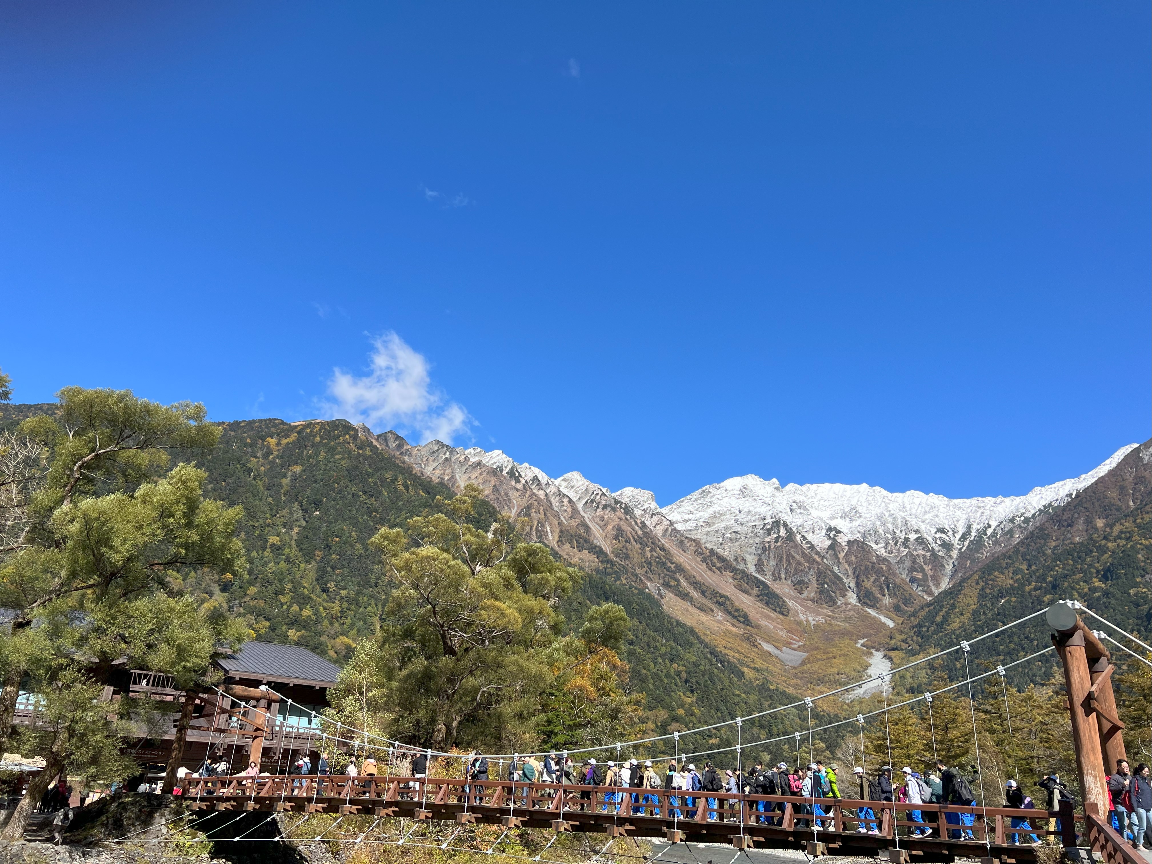
Kamikochi is a tourist resort and summer resort located in the upper reaches of the Azusagawa River in the southern part of the Hida Mountains in western Nagano Prefecture, Japan. It is surrounded by the Hotaka Mountain Range, Yakidake Mountains, and the Jonen Mountain Range. With an altitude of about 1,500 meters, it is part of the Chubu Mountains National Park and is designated as a "Special Scenic Spot" and "Special Natural Monument." There are hot springs here and it is also a base for climbing Mount Hotaka and Mount Guni. It became known to the world after being introduced by the British missionary Weston in the 19th century, and is also known to many mountaineers as a famous scenic spot in Japan. Kamikochi is usually open to tourists from mid-April to mid-November. In winter, Kamikochi is inaccessible due to heavy snowfall.
Plan

One-day trip to the highlands of the Japanese Alps | Departing from Nagoya
Booking starts: 2025-05-30
[Limited time offer] Japan Alps Kamikochi Day Tour | Depart from Nagoya
Booking starts: 2025-05-30
Schedule
08:00
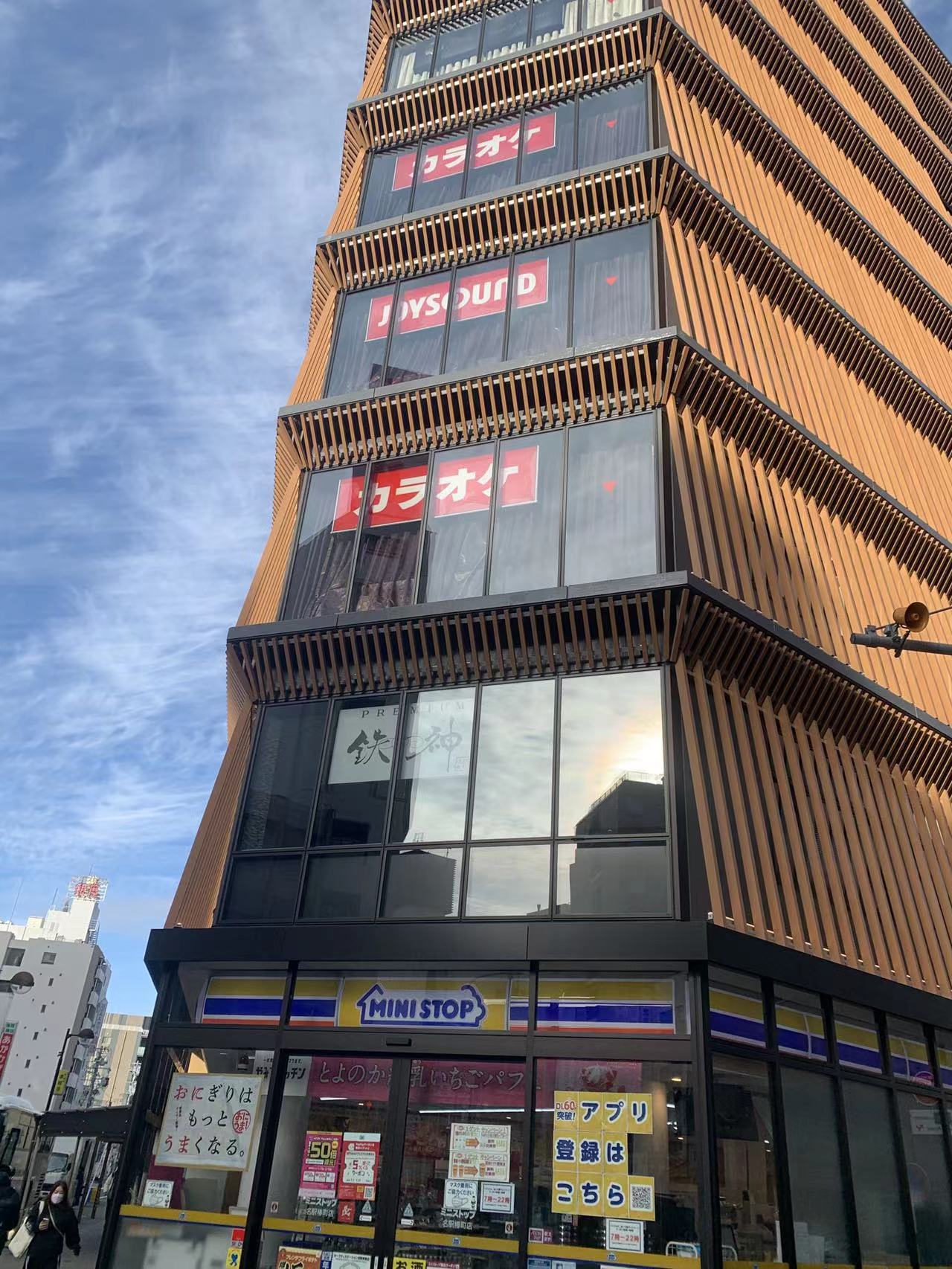
7:50 Gather Departure at 8:00 from JR Nagoya Station Nagoya West Exit (MINI STOP convenience store at the back entrance of BIC CAMERA). Meet and depart
🥾11:30-12:00 Arrive at Kamikochi Kamikochi-hiking (about 3.5 hours, lunch at your own expense) 🧭Recommended route ①: Kamikochi Bus Station > Taisho Pond > Tashiro Pond > Kappa Bridge > Kamikochi Bus Station Taisho Pond ⇄ Azusa River left bank / about 25 minutes on foot (about 1.2km) ⇄ Tashiro Pond and Tashiro Wetlands ⇄ about 20 minutes on foot (about 1.0km) ⇄ Tashiro Bridge and Hodaka Bridge ⇄ Azusa River right bank line / about 10 minutes on foot (about 0.5km ) ⇄ Weston Monument → About 20 minutes’ walk (about 1.1km) ⇄ Kappa Bridge ⇄ About 6 minutes’ walk (about 0.3km) ⇄ Bus stop
Recommended route ②: Kamikochi Bus Stop > Kappa Bridge > Takezawa Marsh > Myojin Bridge > Hotaka Shrine Okumiya & Myojin Pond > Kamikochi Bus Stop Kamikochi Bus Stop ⇄ 5 minutes ((approximately 0.4km)) Kappa Bridge ⇄ Azusa River Right Bank Line / Approximately 10 minutes on foot (approximately 0.5km) ⇄ Takezawa Wetlands Approximately 40 minutes on foot (approximately 2.0km) ⇄ Myojin Bridge ⇄ Hotaka Shrine Okumiya & Myojin Pond
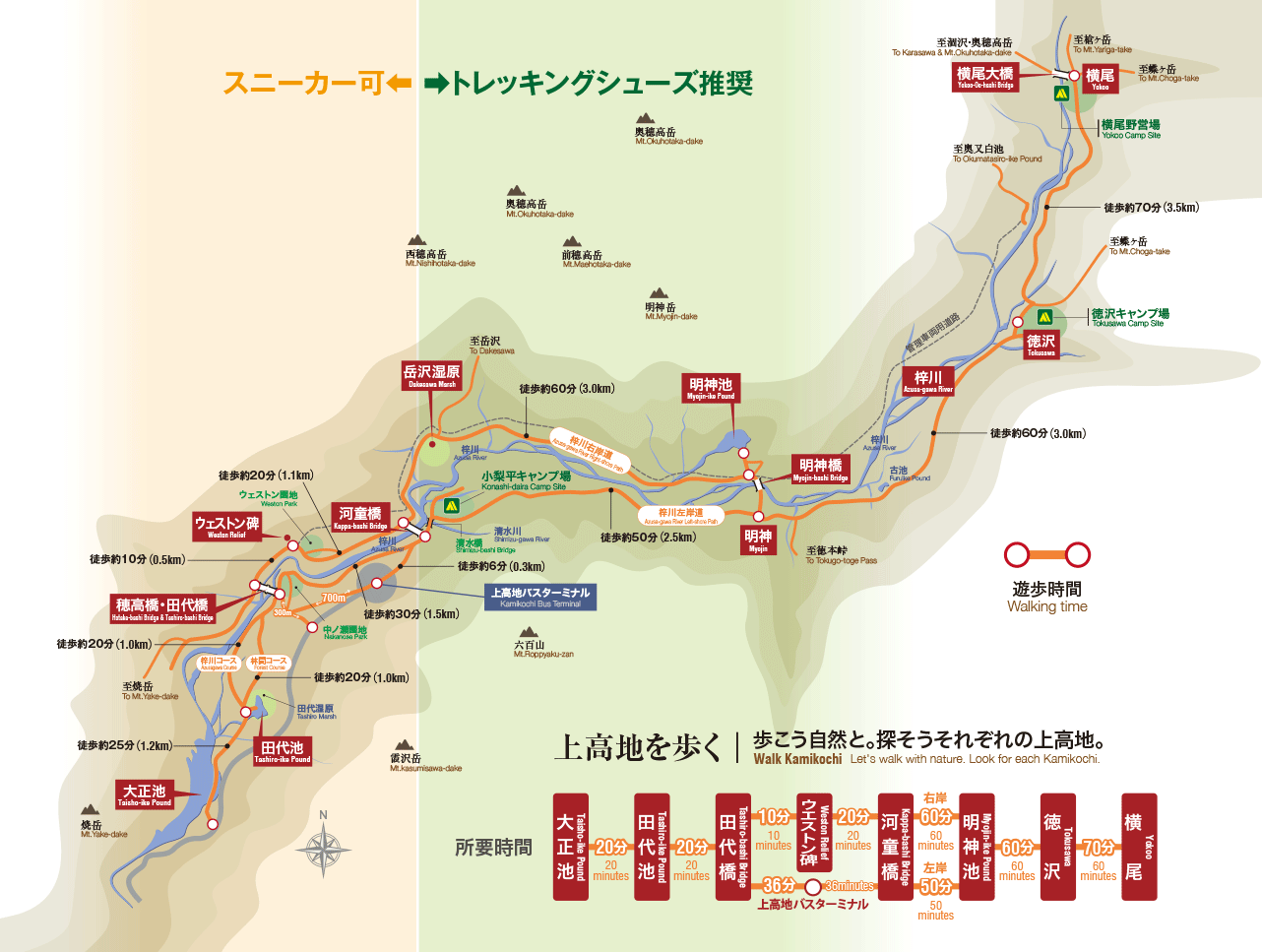
【Taisho Pond】 Taisho Pond is a volcanic lake formed by the eruption of Yakidake volcano. The "dry trees" in the lake will present different dreamy scenery depending on the season and time.

【Tashiro Pond】 Tashiro Pond is a shallow wetland. The fresh greenery in May, the yellow leaves in October, and the thin ice in late autumn are all stunning scenery.

【Kappa Bridge】 Kappa Bridge is a symbolic attraction of Kamikochi, just a 5-minute walk from the bus center. From the bridge, you can overlook the Hondaka Mountain Range, Yakidake, and the water of the Azusagawa River. The May long holiday, summer vacation, and red leaf season attract many tourists from Japan and abroad.

The dazzling scenery of mountains and riverbanks along the way is also a good place to calm down and feel the tranquility surrounded by nature.

【Myojin Pond】 It takes about 60 minutes to walk from Kappa Bridge along the upper Azusa River to Myojin. This place is called the sacred realm of Okumiya of Hodaka Shrine. All kinds of wild plants and wild birds are suitable for calming down and feeling the tranquility surrounded by nature. The view of Mt. Myojin from Myojin Bridge is also very spectacular, attracting many photography enthusiasts.

Hotaka Mountain Range] The Hondaka Mountain Range can be seen from various scenic spots in Kamikochi and is an indispensable part of Kamikochi. Okuho Takadake is the third highest mountain in Japan. It has the titles of "Japan's Hundred Famous Mountains", "New Japan's Hundred Famous Mountains", and "Flower's Hundred Famous Mountains".

Gather at 15:00-15:30 and return to Nagoya (the specific return time shall be subject to the actual notice of the tour guide on the day)
Around 19:30, we arrived at the meeting point in Nagoya and dispersed, and the pleasant trip ended.
Comments
4.7

HyperAir is an intelligent travel platform to your liking, offering the most suitable and value-for-money travel solution, so that you can travel smarter, anywhere.
Travel Agent Licence Number:
HyperAir:354671
Klook:354005
KKday:353679
Trip.com:352367
Holimood:354248
Travel Expert:353969
Wing On Travel:350074

